Sign In | Join Free | My himfr.com
himfr.com

Chengdu Jiebo Technology Co., Ltd.

CHENGDU JIEBO TECHNOLOGY CO.,LTD Main categories: GPS measuring instrument,total station,Level,Theodolite,Measuring accessories

Verified Supplier

2 Years

Home > GNSS RTK Receiver >

Full Wave Sanding T12 RTK GNSS Rover GPS Surveying Instrument Receiver

Chengdu Jiebo Technology Co., Ltd.
Trust Seal
Verified Supplier
Credit Check
Supplier Assessment
Contact Now
    Buy cheap Full Wave Sanding T12 RTK GNSS Rover GPS Surveying Instrument Receiver from wholesalers
     
    Buy cheap Full Wave Sanding T12 RTK GNSS Rover GPS Surveying Instrument Receiver from wholesalers
    • Buy cheap Full Wave Sanding T12 RTK GNSS Rover GPS Surveying Instrument Receiver from wholesalers
    • Buy cheap Full Wave Sanding T12 RTK GNSS Rover GPS Surveying Instrument Receiver from wholesalers
    • Buy cheap Full Wave Sanding T12 RTK GNSS Rover GPS Surveying Instrument Receiver from wholesalers

    Full Wave Sanding T12 RTK GNSS Rover GPS Surveying Instrument Receiver

    Ask Lasest Price
    Brand Name : CHCNAV
    Model Number : T12 rover & base
    Price : $3,200.00
    Payment Terms : L/C, T/T
    Supply Ability : 1 ~ 30 day
    Delivery Time : 30 work day
    • Product Details
    • Company Profile

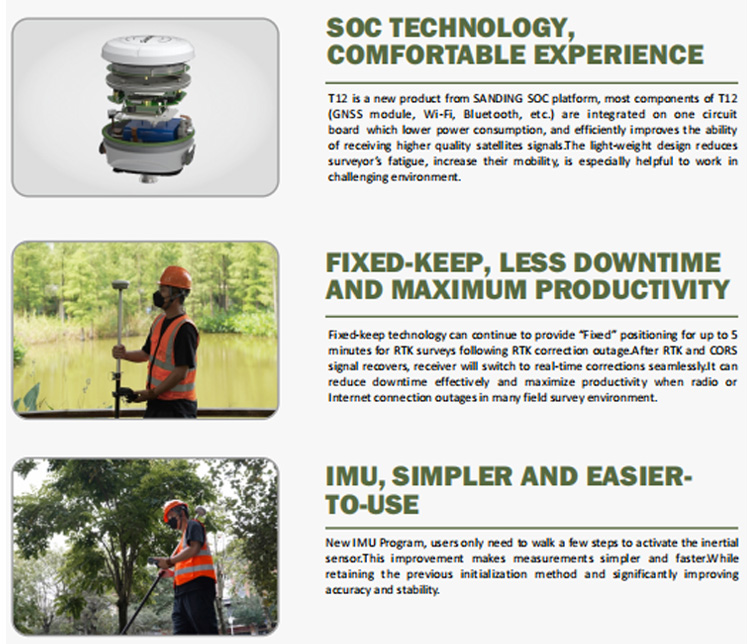
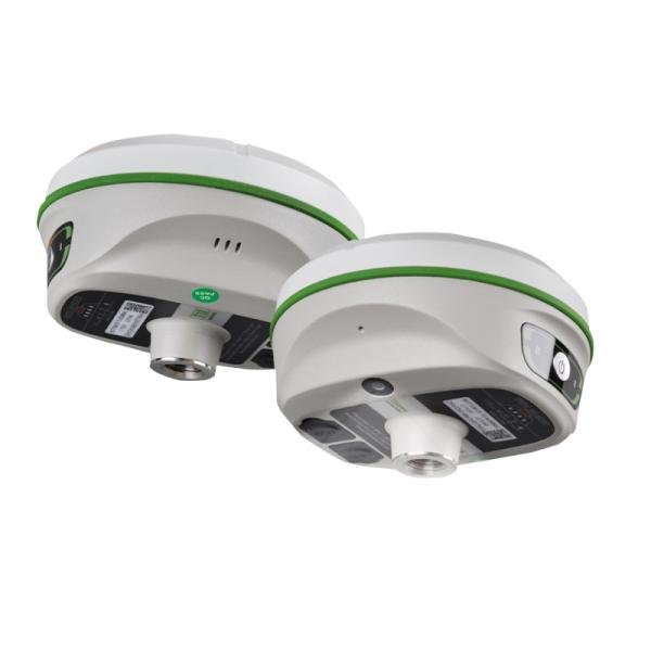
    Full Wave Sanding T12 RTK GNSS Rover GPS Surveying Instrument Receiver

    Best China Sanding Gnss T12 Rtk Gps Surveying Instrument Cheap Sanding Gps Gnss

    Technical Parameters
    GNSSconfiguration
    Number of channels
    1598
    BDS

    B1I,B2I,B3I, B1I,B3I,B1C,B2a,B2b
    GPS
    L1C/A,L2P,L2C,L5,L1C*
    GLONASS
    G1,G2,G3*
    GALILEO
    E1,E5b,E5a,E5 AltBoc*,E6c*
    QZSS
    L1 ,L2C, L5/ IRNSS:L5*/ SBAS:L1C/A,L5*
    Positioning output rate
    1Hz~20Hz
    Differential support
    CMR,RTCM2.X,RTCM3.0,RTCM3.2
    Static format support
    GNS, Rinex dual format static data
    RTK positioning accuracy
    Plane: ±(8+1×10⁻⁶D) mm (D is the distance between the measured points) Elevation: ±(15+1×10⁻⁶D) mm
    (D is the distance between the measured points)
    Static positioning accuracy
    Plane: ±(2.5+0.5×10¯6D) mm (D is the distance between the measured points)
    Elevation: ±(5+0.5×10¯6D) mm
    (D is the distance between the measured points)
    DGPS positioning accuracy
    Plane accuracy: ±0.25m+1ppm;Elevation accuracy: ±0.50m+1ppm
    Initialization time
    <10 seconds
    Initialization reliability
    >99.99%
    IMU tilt compensation
    Additional horizontal pole tip uncertainty typically less than 10mm + 0.7 mm/° tilt down to 30°
    IMU tilt angle:0°~60°
    communication
    NFC wireless communication
    Adopting NFC wireless communication technology, the manual can automatically pair with the host by touching it (the manual
    alsoneeds to be equipped with an NFC wireless communication module)
    WiFi
    802.11b/g access point and client mode, can provide WiFi hotspot service
    Bluetooth
    BLEBluetooth 4.0 standard, support for android, ios cellphone connection
    Wireless modem
    Built-in radio, typically work range can be 8KM Radio repeater
    I/O port
    5PIN LEMO external power port + RS232, 1 radio antenna interface, Type C , Micro SIM card
    frequency band:
    410-470MHz
    Protocol
    SOUTH,Farlink,TrimTalk,ZHD, HUACE
    User Interface
    Buttons
    Power key
    Indicators
    Three indicator lights+Battery display light (at the bottom of the instrument): data light, Bluetooth light, power light (button
    position)
    Electrical physical properties
    battery
    Internal Li-on, 6800mAh, 7.4V
    Power Supply
    9-25V DC, overvoltage protection
    size
    135mm(Diameter)x84.75mm(Height)
    weight
    0.89kg (battery included)
    material
    Magnesium aluminum alloy shell
    Environmental characteristics
    Dust and water release
    IP68 standard, protected from long time immersion to depth of 1m
    Storag
    -55°C~+85°C
    Operating
    -45℃~75℃
    sensor
    temperature sensor
    Built in temperature sensor, using intelligent variable frequency temperature control technology to monitor and adjust the
    hosttemperature in real-time
    System
    model
    H6
    operating system
    Linux
    CPU
    2.0 GHz eight-core processor
    Memory
    3GB RAM
    Storage
    32GB
    Communication
    Network
    TDD/FDD-LTE 4G
    WiFi
    802.11b/g access point and client mode, can provide WiFi hotspot service
    Bluetooth
    BT4.2(BR/EDR+BLE)
    NFC
    Support NFC IGRS
    USB
    Mini USB, supports OTG
    Electrical
    Battery
    7.4V, 3400mAh
    Battery life
    12 hours
    Charging
    < 4 hrs for full charge
    Physical
    size
    131mm*80mm
    Weight
    800g
    Operating temperature
    -35℃ ~ +80℃
    Voice
    IVoice intelligent voice technology, intelligent status reporting, voice operation prompts; Chinese, English, Korean, Russian,
    Portuguese, Spanish and Turkish are supported by default; Support for voice customization
    Data storage/transmission
    Data Storage
    Built-in 4GB solid-state storage, rich sampling intervals, and support for raw observation data collection up to 20Hz
    data transmission
    Supports data transmission such as USB, FTP download, HTTP, etc
    data format
    Static data formats: various formats such as Southern STH, Rinex2.01, and Rinex3.02 Differential data format: RTCM3.0, RTCM3.2
    input and output GPS output data format: NMEA 0183, PJK plane coordinates, binary code Network mode support: VRS, FKP, MAC,
    support for NTRIP protocol

    Full Wave Sanding T12 RTK GNSS Rover GPS Surveying Instrument ReceiverFull Wave Sanding T12 RTK GNSS Rover GPS Surveying Instrument ReceiverFull Wave Sanding T12 RTK GNSS Rover GPS Surveying Instrument Receiver

    Certifications

    Full Wave Sanding T12 RTK GNSS Rover GPS Surveying Instrument Receiver
    Full Wave Sanding T12 RTK GNSS Rover GPS Surveying Instrument Receiver
    Company Profile
    Full Wave Sanding T12 RTK GNSS Rover GPS Surveying Instrument Receiver

    FAQ

    1. who are we?
    We are based in sichuan, China, start from 2016,sell to Africa(30.00%),Southeast Asia(16.00%),Mid East(11.00%),Eastern
    Asia(10.00%),South America(10.00%),Central America(5.00%),South Asia(5.00%),Southern Europe(5.00%),North America(4.00%),Eastern
    Europe(4.00%). There are total about 11-20 people in our office.

    2. how can we guarantee quality?
    Always a pre-production sample before mass production;
    Always final Inspection before shipment;

    3.what can you buy from us?
    GNSS RTK,Total station,Level,Survey accessory,laser rangefinder

    4. why should you buy from us not from other suppliers?
    1.More than 20 years of experience in the trade field. 2.All products will have been strictly quality checked in factory before
    sending out and all products have one year warranty.

    5. what services can we provide?
    Accepted Delivery Terms: FOB,CFR,CIF,EXW,FAS,CIP,FCA,CPT,DEQ,DDP,DDU,Express Delivery,DAF,DES;
    Accepted Payment Currency:USD,EUR,JPY,CAD,AUD,HKD,GBP,CNY,CHF;
    Accepted Payment Type: T/T,L/C,D/P D/A,MoneyGram,Credit Card,PayPal,Western Union,Cash,Escrow;
    Language Spoken:English,Chinese,Spanish,Japanese,Portuguese,German,Arabic,French,Russian,Korean,Hindi,Italian

    Our Service
    Full Wave Sanding T12 RTK GNSS Rover GPS Surveying Instrument Receiver
    Packing & Delivery
    Full Wave Sanding T12 RTK GNSS Rover GPS Surveying Instrument Receiver

    Quality Full Wave Sanding T12 RTK GNSS Rover GPS Surveying Instrument Receiver for sale
    Inquiry Cart 0
    Send your message to this supplier
     
    *From:
    *To: Chengdu Jiebo Technology Co., Ltd.
    *Subject:
    *Message:
    Characters Remaining: (0/3000)